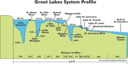
 Today, 20 percent of the world’s fresh surface water is contained in the five great lakes: 5, 473 cubic miles (22, 812 km³), or 6 quadrillion U.S. gallons (22.81 quadrillion litres) in all. It is enough water to cover the contiguous 48 states to a uniform depth of 9.5 feet (2.9 m). The combined surface area of the lakes is 94, 250 square miles (244, 100 km²)— larger than the states of New York, New Jersey, Connecticut, Rhode Island, Massachusetts, Vermont and New Hampshire combined.
The Great Lakes are:
- Lake Superior - the largest by volume and deepest, larger than Scotland or South Carolina
- Lake Michigan - the second-largest by volume and third-largest by area; the only one entirely in the U.S.
- Lake Huron - the third-largest by volume; the second largest in area
- Lake Erie - the smallest by volume and shallowest
- Lake Ontario - the second-smallest in volume and smallest in area, much lower elevation than the rest
Sprinkled throughout the lakes are the approximately 35, 000 Great Lakes islands, including Manitoulin Island in Lake Huron, the largest island in any inland body of water, and Isle Royale in Lake Superior, the largest island in the largest lake (each island large enough to itself contain multiple lakes).
 The Saint Lawrence Seaway and Great Lakes Waterway opened the Great Lakes to ocean-going vessels. However the move to wider ocean-going container ships - which do not fit through the locks on these routes - has limited shipping on the lakes. Despite their vast size, large sections of the Great Lakes freeze over in winter, and most shipping stops during that season. There are some icebreakers that operate on the lakes.
The lakes have an effect on weather in the region, known as lake effect. In winter, the moisture picked up by the prevailing winds from the west can produce very heavy snowfall, especially along lakeshores to the east such as Michigan, Ohio, Pennsylvania, Ontario, and New York. It is not uncommon for heavy snow to occur during completely clear skies because of this phenomenon. The lakes also moderate seasonal temperatures somewhat, by absorbing heat and cooling the air in summer, then slowly radiating that heat in autumn. This temperature buffering produces areas known as "fruit belts", where fruit typically grown farther south can be produced in commercial quantities.
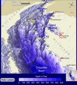
View Great Lakes Bathymetry Explorer and interactive underwater features at Wisconsin Coastal GIS Applications Project.
YOU MIGHT ALSO LIKE


